
Expert warns Rosewood Exuma breakwater could cut beach’s sand supply by 90%
A coastal engineer found Yntegra's environmental impact assessment (EIA) for its Rosewood Exuma resort never properly assessed its proposed marine works in the North Bay and works “should not proceed”
Turtlegrass is publishing a series of expert witness reports on the Yntegra Group's proposed Rosewood Exuma resort on Sampson Cay, each prepared by a specialist for the court proceedings. The first four - Andrew Baker, Mark Gash, Craig Dahlgren and Clive Carpenter - examined the potential impact of the project on the island’s ecology and marine life. The fifth is a coastal engineer, Miles Harris of Smith Warner International Limited (SWIL), who examined how the dock, channel and breakwater would reshape the water, seabed and beaches.
Who is Miles Harris?
Harris is a Coastal and Civil Engineer at SWIL, a Caribbean coastal and marine engineering consultancy. He holds a Master's in coastal engineering and port development and a civil engineering degree from the University of the West Indies, and has been a registered Professional Engineer in Jamaica since 2021. Practicing since 2014, he has worked on more than 50 coastal engineering projects across 13 Caribbean jurisdictions, including The Bahamas, spanning breakwaters, marinas, dredging and coastal modelling.
What was he asked to assess?
Turtlegrass instructed Harris to assess the coastal-process impacts of the marine works in the North Bay of Sampson Cay: the proposed supply dock, dredged access channel and seawall/breakwater, including how they would affect waves, currents, sediment transport, turbidity, seabed conditions and the adjacent beaches. Working in stages from September 2024 to June 2026, he reviewed the EIA, collected field data, and assessed the channel, dredging and breakwater. This included field data collection, bathymetric survey work, current measurements, vessel-based channel design assessment, numerical coastal modelling, and further dredging analysis.
His report was delivered in June 2026.
The central finding: the EIA never properly assessed the impact of the proposed North Bay works and they “should not proceed”
Harris says that without further site-specific assessment, mitigation and management measures, his findings are that the proposed northern supply dock, dredged access channel and breakwater “should not proceed”.
A significant element of his findings is that despite their potential impact on the North Bay of Sampson Cay, the northern works "had not been assessed in sufficient detail" in either the original EIA or the revised version submitted by Yntegra (pg. 12).
Harris notes: “The practical concern is that the EIA did not adequately assess what the northern works would mean for the operation and long-term condition of the area. Without stated design vessel parameters, it is not possible to determine with confidence the required channel depth, width, turning area or true dredging footprint. Without reliable information on seabed levels, sediment type, mobile sand supply and sediment pathways, it is also not possible to properly assess how quickly the channel may infill, whether maintenance dredging would be required, or how the works may affect nearby beaches, sandbars, seagrass, water quality and benthic habitats over time.”
Harris lists several key risks from the proposed North Bay marine works
- The works could lead to the nearby beach overlooking the North Bay being almost entirely starved of sand
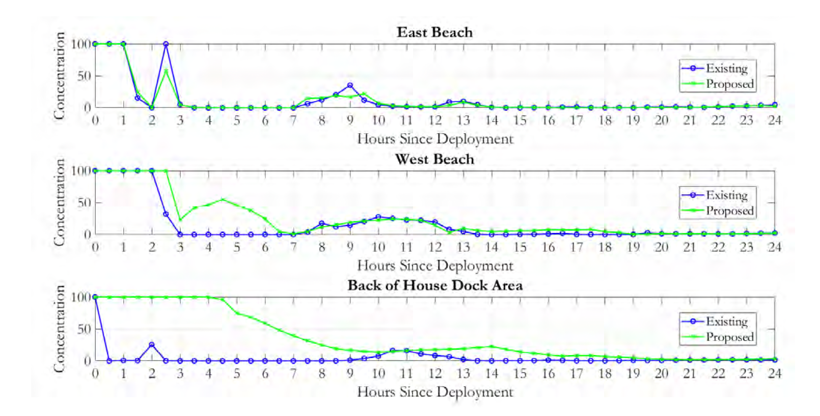
Sand naturally moves through North Bay towards the east beach that looks out over the the bay. Harris's modelling found the breakwater would disrupt that pathway, reducing the offshore sand supply to the beach "by more than 90 percent" during a typical seven-day winter swell event (pg. 14). "The sediment transport results provide the strongest basis for concern about long-term coastal change," he writes, warning of "a risk that the beach may become sediment-starved over time" (pg. 14).
- Key details about what type of vessels would use the channel and dock were left out - leaving too many questions unanswered, including the “true dredging footprint”
The EIA omitted to include evidence of which type of vessels would use the newly-created industrial shipping channel. It also did not describe how the vessel would turn around once it had reached the dock. Harris described these as “significant omissions” (pg. 11).
“Without stated design vessel parameters, it is not possible to determine with confidence the required channel depth, width, turning area or true dredging footprint. Without reliable information on seabed levels, sediment type, mobile sand supply and sediment pathways, it is also not possible to properly assess how quickly the channel may infill, whether maintenance dredging would be required, or how the works may affect nearby beaches, sandbars, seagrass, water quality and benthic habitats over time,” he adds (pg. 15).
Deeper dredging brings with it significantly greater impacts on the marine environment. Yet while dredge volumes rise sharply as deeper channels are dredged - from roughly 4,000 m³ requiring removal at 7 ft of depth required to over 21,000 m³ at 12 ft (pg. 14) - the Yntegra EIA did not suggest any larger or alternative vessel design to “justify the deeper scenarios as operationally necessary." (pg. 14).
- The channel may become unnavigable without significant ongoing maintenance dredging
A single seven-day swell "could deposit up to approximately 0.3 m, or about one foot, of material" in sections of the channel, and with 13 - 17 such events a year, maintenance dredging is likely. That infilling "could reduce the available depth to the point where the channel may no longer be safely navigable" (pg. 14).
His conclusion: the Rosewood Exuma project should not proceed without further assessment, mitigation, management measures
Given that the North Bay site is tidally active; meaningful dredging is required for vessel access; the breakwater would alter waves and currents; sediment pathways would be interrupted; the beach system could become sediment-starved; and deeper dredging scenarios would increase environmental disturbance, Harris concludes the marine works in the North Bay "should not proceed on the basis of the original EIA alone without further site-specific assessment, mitigation and management measures" (pg. 15).
These questions "should have been assessed before any conclusion could safely be reached that the coastal impacts of the northern works are low, acceptable, or adequately mitigated" (pg. 15).
Stop the work until the real risks are assessed
Harris reaches the same destination as the experts before him - that this is a project advanced on an evidence base that does not answer basic questions. His review confirms what we have said from the start: Yntegra's northern works would permanently alter the North Bay, the EIA never properly assessed that risk, and the works should not proceed without proper risk assessment.
Harris's report is the fifth in our series on Yntegra's Rosewood Exuma project.
Read Harris's full report for yourself, and watch out for the rest.
Latest Blog